| ||
|
| ||
|
All-Russia Geological Institute for Geology and Mineral
Resources of World Ocean (VNIIO), St. Petersburg, Russia, |
![]()
|
Abstract Vinogradov V.A., Gusev E.A., Lopatin B.G.
Structure
of the East Russian Arctic shelf. // Geological-geophysical features of the
lithosphere of the Arctic Region. St. Petersburg, VNIIOkeangeologia, 2004. № 5,
p.
202-212. The results of the five year work devoted to preparation of the sheets of
State Geological Map of Russia (1:1 000 000 scale, East Arctic shelf) are
published in this article. New obtained bathymetric, magnitometric, gravimetric,
seismic, seismologic and geological data were used for this paper. The
stratigraphic scales between the Russian East Arctic and Chuckchi Sea shelves
were correlated with using of the borehole data from Alaska shelf of USA. Fig. 4,
references
– 17.
|
Introduction
The Laptev, East Siberian, and Chukchi sea shelves (Fig. 1) and their transition to deep water basins are still in a very early stage of geological exploration. All existing bathymetric, magnetic, gravimetric and geologic data, including shallow wells in the New Siberian Islands area and deep wells in the US sector of the Chukchi Sea shelf, were recently summarized in the process of compilation of the State Geological Map of the Russian Federation at a scale of 1:1,000,000. The work was carried out by the Geological Map Division of VNIIOkeangeologia during the last 7 years and includes a special geologic legend that unifies the entire offshore area. The level of earth science exploration varies drastically from one area to another, and even in the relatively better studied parts it remains insufficient for unambiguous characterization of geological structure and history, especially in places where subbottom geology is imaged exclusively on the basis of geophysical evidence and cannot be reliably correlated with island outcrops. Consequently, the views expressed by the authors remain to a large extent speculative and will have to be verified by future research activities.
In the present study attention is mainly concentrated on the specific structure
of the sedimentary cover--basement age and structure are discussed briefly. The
most relevant information was obtained from deep seismic profiling, which gives
data on the structure of the basement surface, tectonic structures, and
thickness and unconformities within the sedimentary cover. An elaboration of the
tectonic model for all of the Russian eastern Arctic shelf is accompanied by
critical discussions of the existing views on problems which have been hampered
by absence of deep offshore wells. That is why the age and nature of the
basement and sedimentary cover remain thus far, speculative.
Data sets
This paper is based mainly on the State Geological Map at a scale of
1:1,000,000, every sheet of which presents a separate geoinformational system
(GIS) layer, including initial geological and geophysical databases along with
geological maps. A set of maps consists of bedrock, Quaternary, bottom
sediments, geomorphologic, tectonic, and deep-structural maps. The essential
parts of the digitized database comes from geological observations during
mapping of the mainland and islands, provided in the eastern Arctic region by
the Russian Geological Survey from the middle of the last century. The
geological investigations of the offshore area are rather poor. They include
bottom sampling, piston cores and rare shallow seismic profiles.
Several shallow boreholes were collected around the New Siberian Islands, and
deep ones on the Alaska Shelf (USA). The major source of information used in
this presentation therefore come from various geophysical methods of
investigations by the Marine Arctic Geological Enterprise (MAGE) of Murmansk (Sekretov,
1998; 1999a; 1999b; 1999c), Laboratory of Regional Geodynamics (LARGE)
from Moscow (Drachev et
al., 1998), and joint research by the oil company “Sevmorneftegeofizika”
of Murmansk and the Geological Institute BGR of Hannover, Germany (Roeser et al., 1995; Hinz et al., 1998; Franke et
a.l, 1999), and joint research by the oil company “Dalmorneftegeofizika”
of Yuzhno-Sakhalinsk, Russia and Halliburton (USA).
Stratigraphy of the sedimentary cover
Two large provinces are distinguished on the Russian eastern Arctic Shelf that
are defined by the age of their folded basement (late Mesozoic and Caledonian)
and differ from each other by the age of their sedimentary cover. The boundary
of the provinces can be traced to the western Chukchi and East-Siberian seas
using
seismic reflection data and borehole sections from northern Alaska and
the Chukchi Shelf, where two types of the sedimentary cover are established with
good confidence. American geologists (Grantz
et al., 1975; 1990 and Thurston and Theiss, 1987) divide the sedimentary
cover into 2 sequences--Ellesmerian (Late Devonian to Early Cretaceous) and
Brookian (Early Cretaceous to Cenozoic) with the regional Lower Cretaceous
unconformity (LCU) at the base of the Barremian Stage separating them.
The Ellesmerian Sequence is spread only in the province with Caledonian
basement, and its source rocks were located to the north in the area of the
present day Arctic Ocean. Brookian Sequence sediments are distributed in both
provinces, covering the Ellesmerian Sequence in one, and in the other, late
Mesozoic folded basement rocks where they constitute the whole volume of the
sedimentary cover. The boundary between the late Mesozoic and Caledonian
basements and consequently the southern boundary of the Ellesmerian Sequence
distribution is traced from Cape Lisburne in western Alaska, west along the
northern margin of the Herald Arch 100-150 km north of Wrangel Island, and on
across the East-Siberian Sea to Vil`kistsky Island, in a southwest direction
from the De-Long Archipelago. The Ellesmerian Sequence can be distinguished on seismic records in the North Chukchi basin, where its thickness reaches 7-8 km, and the total thickness of the sedimentary cover is no less than 20 km. The assumption of Grantz et al. (1975) about the presence here of the Franklinian Sequence at the base of the cover is hardly probable, because his data show only Endicott Group strata in some grabens on the Chukchi Shelf that may be as thick as 7 km, which does not leave much room for Franklinian Sequence strata in the North Chukchi Basin. After our interpretayion of a seismic profile SC-90-01 of “Dalmorneftegeofizika” Enterprise the sedimentary cover of the North Chukchi depression is divided into 7 seismic unites by reflectors (Ch-I)-(Ch-VII), and their correlation to the reflectors of Thurston and Theiss (Thurston & Theiss, 1987) is shown on Fig. 2.
Older, basal sedimentary cover exists north of the
North Chukchi basin, as evidenced from Lower Paleozoic rocks dredged on the
continental slope, on the Mendeleev Ridge, and on the steep eastern slope of the
Northwind Escarpment, where a continuous stratigraphic section beginning with
Cambrian rocks was reported (Grantz et
al., 1998). Similar data were obtained by Russian investigators in the
southern part of the Mendeleev Ridge, where paleontologically dated
carbonate-terrigenous Upper Silurian to Lower Permian rocks were dredged (Kaban’kov
et al., 2001). Low lithification and the occurrence of kaolinitic cement
in sandstones, proves these dredged Paleozoic rocks are strata from sedimentary
cover. On the East-Siberian shelf, Ellesmerian Sequence strata were recognized on a LARGE seismic profile (Fig. 3) 170 km east-northeast of Novaya Sibir` Island (Drachev et al., 2001). Here, two reflectors “A” and “B” are distinguished beneath reflector “B-1” (LCU). The strata between these reflectors thin and are truncated by reflector B-1 to the north (toward the De-Long rise), but to the south, they increase to 7 km in thickness. Besides the increase in thickness, there is an increase in deformation of the strata, which gradually becomes more intense until it is manifested as a rather sharp transition to acoustic basement. We believe this transition of Ellesmerian Sequence to the folded state marks the boundary between late Mesozoic and Caledonian basement provinces.
On Novaya Sibir` Island, drilling revealed late Mesozoic basement (folded
Jurassic terrigenous rocks) beneath Pliocene–Quaternary sediments. Magnetic
anomalies over Novaya Sibir` Island are similar to the anomalies seen from the
cassiterite-bearing granites of Bolshoy Lyahovsky Island.
Placer cassiterite found on Novaya Sibir` Island confirms the presence of
stanniferous granites in the basement. And, in the basal Pliocene layers
overlying the deformed Jurassic rocks, grains of molybdenite and sphalerite are
also found.
Caledonian basement is exposed on Henrietta Island where outcrops of folded
volcanic and clastic rocks, bearing sills, dykes and sheets of basalts,
andesite-basalts, and porphyritic diorite occur (Vinogradov
et al., 1974). Basalts and porphyritic diorite dated bv the
potassium–argon method are 310-450 ma and porphyritic diorite dated using the
argon–argon method are in the 400-440 ma interval. Fragments of gneissic,
granitic, and quartzitic rocks and schists in gritstone of Henrietta Island are
evidence that the Caledonian fold basement zones in the De-Long rise province
include blocks of older consolidation. More evidence of these is the presence of
flat-lying Cambrian and Ordovician strata on Benetta Island, but these lower
Paleozoic rocks may not be part of the sedimentary cover
because seismic reflection signatures typical of sedimentary cover are
absent on the nearby profiles.
The Ellesmerian Sequence is divided by American authors (Grantz et al., 1975; 1990 and Thurston and Theiss, 1987) into two
parts: Lower Ellesmerian and Upper Ellesmerian Sequences, separated by Permian
unconformity (PU) at the base of Upper Permian strata. In the wells drilled on
the Alaska coast, the sedimentary cover begins with the Upper Ellesmerian
Sequence, and the “PU” reflector marks the acoustic basement. However, in the
deep depressions where the “PU” horizon separates subparallel reflectors of the
Lower and Upper Ellesmerian sequences, it may be lost. This is what we believe
happened on the seismic profile in Thurston and Theiss (1987) Plate 5, published
before the wells in the Chukchi Sea were drilled. Within the Ellesmerian
Sequence below the Lisburne Group, there is a well expressed reflector identified as an unconformity between Endicott Group
(D3-C1) and Lisburne Group (C2-3). On the
southern slope of De-Long rise, the presence of Lisburne Group rocks is
confirmed by dredge samples that contained fragments of siliceous limestone with C2-3
fauna in Neogene volcanics of Zhokhov Island.
The Brookian Sequence (Barremian Stage to Cenozoic) is divided by American
scientists into Lower Brookian (K1br-al) and Upper Brookian (K2-KZ)
sequences. In our interpretation, based on seismic data analysis across the
whole eastern Arctic Shelf (from the Laptev to Chukchi seas), we propose
dividing the stratigraphic section into Cretaceous (K1br-K2)
and Cenozoic parts. The lower sequence is much thicker and is characterized by
numerous plastic and disjunctive deformations as a result of fragmented
topography of the basement surface. The upper sequence is a continuous but less
thick mantle type deposit. It is seismically transparent and is not disturbed by
syndepositional deformations.
Discussion
The uniform structure of the whole sedimentary cover suggests its uniform age.
For a long time this postulate did not seem to apply for the Laptev shelf, where
on the west it was thought to be late Proterozoic to Cenozoic in age. However,
new multichannel seismic data, obtained by Marine Arctic Geological Expedition
(MAGE, Murmansk, Russia) and by Regional Geodynamic Laboratory (LARGE, Moscow,
Russia) do not support this conception (Drachev et al., 1998; Vonogradov &
Drachev, 2000; Gusev et al., 2002). On the seismic profiles near the southern
coast of the Laptev Sea (Oleneksky Bay, Buor-Khaya Bay) a floor of sedimentary
cover lies on the Late Mesozoic folded basement, protruded on the coast. On the
seismic profile along the Khatanga Bay one can see a sharp changing in the wave
characters at the front of Late Mesozoic folding. This front is traced from the
eastern coast of Bolshoi Begichev Island to Tsvetkov Cape on the
southern-eastern coast of the Taimyr Peninsula (Vinogradov & Drachev, 2000).
Horizontal seismic reflectors, typical for the thick sedimentary cover of the
northern flank of the Siberian Platform are sharply terminated at this boundary.
On the northern-eastern fragment of the seismic profile the wave record becomes
chaotic similar to the acoustic basement along all the profile. It confirms that
the cover of the Siberian Platform does not continue beyond the Khatanga Bay.
There is still a difference between the west and central parts of the Laptev Sea
and its eastern part. In the eastern part the main stage of folding is connected
with EarlyCretaceous
time because coal-bearing molasse rocks of Aptian-Albian age on Kotel`ny Island
overly folded Paleozoic and Mesozoic formations with a sharp unconformity. On
the central and western part of the Laptev Shelf, riftogenous processes were
superimposed at the final stage of the Early Cretaceous deformation resulting in
rather weakly deformed basement rocks being buried under rift formations.
The Late Cretaceous formation history of the sedimentary cover needs a special
discussion. During Late Cretaceous time all of the area to the northeast of the
Lena River mouth underwent an intense denudation. This conclusion is supported
by the fact that the main stage of intrusive activity including large granite
batholiths in northeast Russia took place at the end of Early Cretaceous to the
beginning of Late Cretaceous, and erosion products are found in Paleocene
sediments. Further evidence is deep denudational truncation and weathering crust
reported in the Tiksi Bay area, where Paleocene sediments, including quartz
siltstones, cover the greenshist Verkhoyan suite. If to adopt a depth of
granitic massives formations equal no less than 3 km, a volume of denudated
rocks on the North-East of Russia for the Late Cretaceous time (from granitic
origin up to their denudation) may make up about 6,5 million km3.
On the adjacent shelf, continental slope and Eurasian deep basin, nearly 7.5
million km3 of sediments were deposited. A quiescent stage set in
between the Mesozoic and Cenozoic manifested by Paleocene peneplain facies in
the areas of Tiksi Bay, Yano-Indigirskaya lowland, and New Siberian Islands. On
seismic records this boundary is expressed by a high contrast regional
unconformity between the Upper Cretaceous strata exhibiting numerous reflectors
with syndepositional deformation filling rift grabens, and overlying continuous
seismically “transparent” Paleocene strata.
In the North Chukchi basin, Upper Cretaceous strata with widely spread
clinoforms acquire the role of an independent sequence, separated from
Barremian–Albian rocks by a sharp angular unconformity (Thurston and Theiss,
1987, Plate 7).
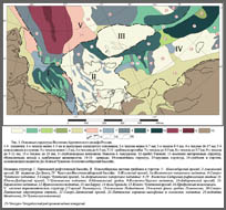
Structure Provinces Structure of the sedimentary cover on the eastern Arctic shelf of Russia generally is an assemblage of large basins and rises separating zones of persistent depressions such as the Laptev basin, New Siberian System of horsts and grabens, Chukchi-East-Siberian basin, De-Long rise and series of perioceanic depressions along the Shelf margin (Fig. 4).
Laptev basin occupies the central and western parts of the Laptev Sea. It is
about 400 km wide on the north near the continental slope, and does not exceed
100 km in width on south-southeast in the Buor-Khaya Bay area. On the south and
west, the Laptev basin is bounded by mountainous–folded formations of
Mesozoides, and from the east by Lazarev fault separating the basin from New
Siberian System of horsts and grabens. The internal structure of the Laptev
basin is rather complex due to numerous faults, uplifts and troughs. Sedimentary
strata reach thicknesses of 10-12 km in troughs and thin to 5-6 km over horsts.
The New Siberian System of horsts and grabens, between two basins – Laptev and
Chukchi-East Siberian, extends from the continent to the shelf margin, it is 600
km wide in the south and about 400 km in the north. On the whole, it is an
uplifted province with reduced and discontinuous cover, except Novosibirsky and
Anisinsky grabens, where the sedimentary cover is thickest. The structures of
the western and the eastern slopes of the New Siberian System are not alike. The
structure of the western slope is highly contrasting due to numerous horsts and
grabens. The eastern slope is rather gentle with single
grabens. In the axial part of New Siberian System, basement is exposed. The
axial zone is a direct continuation of the Lomonosov Ridge, which can be
regarded as a submeridional horst. The western slope of the Lomonosov Ridge is
also dissected by numerous horst and grabens, and the eastern slope is
relatively gentle with rare grabens. This resemblance between New Siberian
System and Lomonosov Ridge suggests that they are part of a transregional
positive tectonic feature that trends from the continent, through the shelf, to
the Arctic Ocean basin. The axial zone of this transregional feature is traced
further on land in the Yano-Indigirskaya lowland as basement protrusions,
including several granite massifs of Cretaceous age, collectively named the
Chokhchuro-Chekurdakhsky row.
The Chukchi-East-Siberian Basin is the largest structural province of the
eastern Arctic shelf. It extends in latitudinal direction over 1300 km, widening
from 450 km in the west to 900 km in the east (in American part of Chukchi Sea).
From the west, the basin is bounded by the New Siberian System of horsts and
grabens, from the north by De-Long Rise, from the south by rangy Mesozoides of
North-East Russia. The coastal lowlands are part of the southern flank of the
basin. To the south of the Herald Arch, the basin is bounded by Alaska
mountains, and in the north – by the Barrow Arch.
The basin can be divided into northern and southern parts by the different ages
of basement. The northern province is underlain by Caledonian basement, the
southern province by late Mesozoic basement. The provinces are separated by
large high–angle faults. In the northern province, two deep
depressions–Zhokhovsky and North-Chukchi--are distinguished, separated along 174
degree west longitude by the Jannetsky transverse uplift.
The Zhokhovsky depression extends for 600 km from the east to where it is 200 km
wide to the west where it gradually narrows and disappears in the boundary zone
between the New Siberian System of horsts and grabens and De-Long Rise. The
thickness of Upper Paleozoic–Cenozoic cover in the axial zone of the depression
reaches 10-12 km.
The North-Chukchi Basin within the Russian shelf is also traced for 600 km and
its width varies from 250 km on the east to 160 km on the northwest. This basin
is notable for its great cover thickness. On seismic records acoustic basement
is recognized at the depth of 18 km with a good confidence (Fig 3). The
structure is asymmetrical: its southern flank dipping steeper than its northern
flank. The axial zone and the northern flank is disturbed by the transverse
Andrianovsky uplift along the 170º meridian. The uplift is contoured by
Barremian-Albian (LCU) isolines (and in older strata), having an amplitude of up
to 3000 m. But it is not obviously expressed at the Upper Cretaceous floor level
(mBU). Twenty to twenty five kilometers north, the axial zone of the North
Chukchi basin shifts to younger strata.
The North-Chukchi basin is dissected by sublatitudinal and younger submeridional
faults. Sublatitudinal faults often bound half grabens on the southern flank of
the basin. Submeridional faults truncate Upper Cretaceous rocks and bound
grabens and horsts, which are expressed in sea floor topography. In the north,
the basin is bounded by the arch-like North Chukchi rise, which extends
west-northwest for 500 km and varies from 50 to 75 km in width. To the
northwest, the North Chukchi rise conjugates with the southeastern flank of
De-Long rise, and on east-southeast probably with the Barrow Arch. Sedimentary
cover thickness within the North Chukchi rise is estimated at 6-7 km.
The southern part of the Chukchi-East-Siberian basin differs from its northern
part by the presence of predominantly submeridional structural trends inherited
from the late Mesozoic basement. Sublatitudinal strike features typical of the
northern part are partly preserved only on the Chukchi Shelf, such as the Herald
Arch with thin sedimentary cover and basement projections (Wrangel Island), and
the South Chukchi depression with the Cretaceous-Cenozoic cover up to 4-6 km.
Over most of the East-Siberian shelf the structural trend is predominantly
submeridional with symmetrical features. The axial zone of the structural
assemblage is characterized by the Melvillian graben, where Aptian-Cenozoic
cover reaches 10 km. Actually, it can be regarded as a zone of extension, on the
both sides of which there are uplifts: Chukchi and East-Chersky, flanked again
by subsidence features: the South-Denbarsky and Ambarchiksky garbens. The
basement fault zones, responsible for origin of these structures extend to the
north, dissecting Zhokhov depression and De-Long rise. It is very likely that
submerged parts of the East-Siberian shelf have riftogenous nature, similar to
the Laptev basin.
The De-Long rise has a block-like round-to-triangular form, elongated in a
west-northwest direction for 800 km. It is 400 km wide in the west and narrows
to the east to 150 km. For the most part it is covered by thin (less than 1 km)
Cretaceous-Cenozoic mantle type deposits with several projections of Caledonian
and probably older basement. On the slopes of De-Long rise the cover is 3-4 km
thick, underlain by Mesozoic and Paleozoic strata. The rise is dissected by
faults, bounded grabens and horsts.
Conclusions
Analysis of the obtained results permits us to make three main conclusions on
the age and structure of the sedimentary cover of the eastern Arctic Shelf of
Russia.
1.
The sedimentary cover structure was formed during two stages that
resulted in two structural trends and related tectonic features. The time
boundary between these stages lies in Barremian-Aptian. In the older stage
sublatitudinal trends predominated, and in younger stage--submeridional.
2.
Older sublatitudinal zonation was caused by structural features of the
fold basement, whereas younger submeridional zonation appeared as a result of a
unique ocean and shelf riftogeneous processes. Structural elements of the Arctic
Ocean, such as the Eurasian Basin, Lomonosov Ridge, Mendeleev Rise, and Chukchi
Basin generally express continuations of the shelf structure in their
sedimentary cover. Besides the mentioned structural relationships between the
ocean and shelf, one more is important–the position of thick lens of the Lower
Brookian Sequence in the North-Chukchi basin just opposite the Chukchi basin in
the Arctic Ocean, between Mendeleev Rise and Chukchi Plateau.. 3. An active riftogenous process started simultaneously over all of the eastern Arctic Shelf at the end of Early Cretaceous and finished by the beginning of the Cenozoic, and an active tectogenesis migrated in time toward the Arctic Ocean. In the Cenozoic on the shelf-ocean boundary, perioceanic depressions were formed, whereas on the shelf in a quiescent environment, a thin and continuous sedimentary mantle was deposited.
References
1.
Drachev S.S., Savostin L.A., Groshev V.G. &
Bruni I.E.,
Structure and geology of the continental shelf of the Laptev Sea, Eastern
Russian Arctic. // Tectonophysics, №298, 1998, p. 357–393.
2.
Drachev S.S., Elistratov A.V., and Savostin L.A.
Structure and Seismostratigraphy of the East Siberian Sea Shelf along the
Indigirka Bay-Jannetta Island Seismic Profile. Transactions (Doklady) of the
Russian Academy of Sciences/Earth Science Section, 2001, Vol. 377, № 3,
March-April, p. 293. (in Russian).
3.
Franke D. & Hinz K.,
Lapseis: Untersuchungen zur Neotektonik in der Laptev-See, Ostsibirischen See
und auf dem angrenzenden NE-Sibirischen Festland mit Seismologischen
Breitbanddaten. EndBericht uber die arbeiten der BGR zum project. 1999. 122 p.
(in German)
4.
Grantz A., Clark D.L., Phillips R.L. et al.
Phanerozoic Stratigraphy of Northwind Ridge, Magnetic anomalies in the Canada
basis, and the geometry of rifting in the Amerasia basin, Arctic Ocean.
Geological Society of America Bulletin, Iuni 1998, v. 110, no.6, pp. 801-820.
5.
Grantz A., Holmes M.L., Kososki B.A.
Geologic framework of the Alaskan continental terrace in the Chukchi and
Beaufort Seas. – In: Canada`s continental margins and offshore petroleum
exploration: Canadian Society of Petroleum Geologists Memoir 4, 1975, p.669-700.
6.
Grantz A., May S.D., Hart P.E.
Geology of the Arctic Continental Margin of Alaska. - In: The Arctic Ocean
Region. The Geology of North America. Volume L. 1990, p. 257-288.
7.
Gusev E.A., Zayonchek A.V., Mennies M.V., Rekant
P.V., Roudoy A.S., Rybakov K.S., Chernyh A.A.
The End of the Gakkel Ridge In The Laptev Sea. – In: Geological-geophysical
features of the lithosphere of the Arctic Region. St. Petersburg,
VNIIOkeangeologia, 2002. № 4, p. 40-54 (in Russian).
8.
Hinz K., Delislande G., Cramer B., Franke D.,
Fieguth U., Lindemann F., Neben S., Tostmann H. & Zeibig M.,
Cruise report: marine seismic measurements and geoscientific studies on the
slope and shelf of the Laptev Sea & East Siberian Sea / Arctic with M.V. «Akademik
Lazarev», I.V. «Kapitan Dranitsin», Preliminary scientific results. – BGR-Report,
№116.693, 1997. 161
p.
9.
Kaban’kov V.Ya., Andreeva I.A., Ivanov V.L.
Dropstones in bottom sediments from Mendeleev Rise (Arctic Ocean), and its
significance for geodynamic position. Geology of seas and oceans. XVI Marine
School. Abstracts. Vol. 2. Moscow. 2001, p. 32-33 (in Russian).
10.
Roeser H.A., Block M., Hinz K. & Reichert C.,
Marine Geophysical Investigations in the Laptev Sea and the Western Part of the
East Siberian Sea. Berichte zur Polarforschung №176, 1995, p. 367-377.
11.
Sekretov S.B.
Petroleum Potential of Laptev Sea Basins: Geological, Tectonic and Geodynamic
factors. Polarforschung 68, 1998, p. 179-186.
12.
Sekretov S.B.
Eurasian Basin – Laptev Sea Geodynamic System: Tectonic and Structural
Evolution. Polarforschung 69, 1999, p. 51-54.
13.
Sekretov S.B.
Northwestern Margin of the East Siberian Sea: Structure, Sedimentary Basin
Development and Hydrocarbon Possibilities. Polarforschung 69, 1999, p. 155-162.
14.
Sekretov S.B.
Southeastern Eurasian Basin Termination: Structure and key episodes of tectonic
history. Polarforschung 69, 1999, p. 251-257.
15.
Thurston D.K., Theiss L.A.
Geologic report for the Chukchi Sea Planning Area, Alaska. United States
Department of the Interior Minerals Management Service. Outer Continental Shelf
Report 87-0046, 193 p. Anchorage, Alaska, 1987.
16.
Vinogradov V.A., Gaponenko G.I., Rusakov I.M.
Tectonics of East Arctic Shelf of the USSR. NIIGA reports, Vol. 171, Leningrad,
NEDRA, 1974, 144 p (in Russian).
17.
Vinogradov V.A., Drachev S.S.
Tectonic nature of the basement of East Laptev Shelf. Transactions (Doklady)
of the Russian Academy of Sciences/Earth Science Section, 2000, Vol. 372, № 1,
p. 72-74. (in Russian).
|


|
Reference to this paper:
Vinogradov V.A., Gusev E.A., Lopatin B.G. Structure of the East Russian Arctic shelf. // Geological-geophysical features of the
lithosphere of the Arctic Region. St. Petersburg, VNIIOkeangeologia,
2004. № 5, p. 202-212
|
![]()